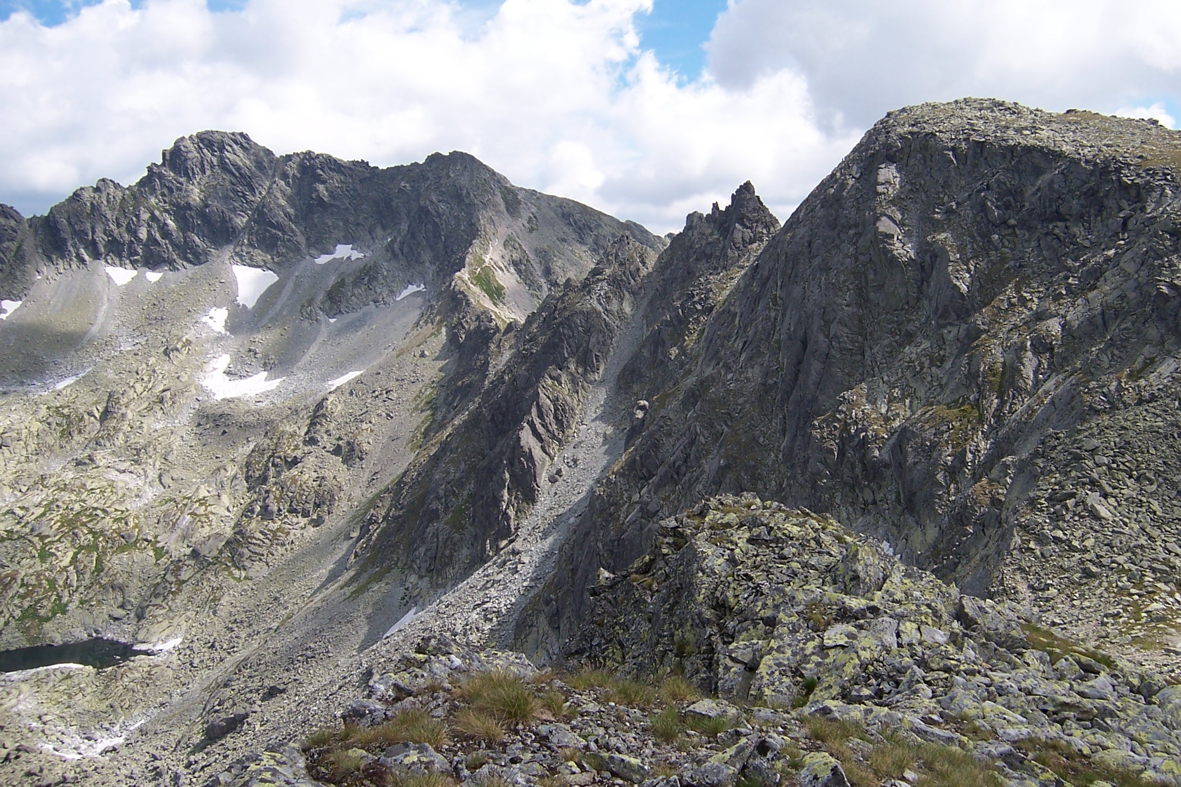
W-Carpathians / High Tatra, (Europa , Slovakia)
Region coordinates
| Latitude | 49.17 DD |
| Longitude | 19.99 DD |
Summits
| KRA | 2336 m | upper alpine |
| SED | 2061 m | lower alpine |
| VEK | 2052 m | lower alpine |
| KRI | 1919 m | treeline ecotone |
Short description & land use (current/history)
The Tatras are situated in the northern part of Slovakia. They are bordered by geographical co-ordinates of 49°05'-49°20' northern latitude and 19°35'-20°25' eastern longitude.
The Tatras are a boundary mountain range. The Slovak-Polish frontier is in the north of the country and it runs mostly through the Tatras. In the north-western part of the Vysoké Tatry Mts. (High Tatras) the state border is running on the main ridge of the mountain range is and coincides with the course of the geographic parallel. As the border line reaches the top of the Rysy peak, it turns to the north onto the lateral ridge of the Žabie štíty peaks and drops to the bottom of Bielovodská dolina valley. Four fifths of the Vysoké Tatry Mts. are in the Slovak territory and one fifth is in Poland. The entire mountain range of the Belianske Tatry Mts. is in the Slovak territory. In the west the limits of the region of Vysoké and Belianske Tatry Mts. coincide with the border between the Západné Tatry Mts. (Western Tatras) and Vysoké Tatry Mts. It passes from the Laliové sedlo saddle over the Tichá dolina valley to the Závory saddle in the lateral ridge of Liptovské kopy Mts. It descendes from the Závory saddle to the bottom of the Kôprová dolina valley and continues along its axis up to Podbanské. In the south the Tatras abruptly pass to Popradská kotlina basin occupying the eastern part of the Podtatranská kotlina basin. The contact zone between the basin and the mountain range and simultaneously the southern edge of the region are the foothills of the Tatras. The Podtatranská brázda furrow represents the northern or north-eastern limits of the Tatras. The name of this elongated depression changes in the territory we are talking about Ždiarska brázda furrow and it separates the Belianske Tatry Mts. from the Spišská Magura Mts.
The region of the Vysoké and Belianske Tatry Mts. is one unit. It represents one province, Prešovský kraj and one district: Poprad. The majority of the territory is in the cadaster of Vysoké Tatry, which with is surface of 39,816 hectares, is the largest in Slovakia.
Geomorphologically, the Tatras are divided into two units: the Západné Tatry Mts. and the Východné Tatry Mts. (Eastern Tatras). The Podtatranská kotlina basin is divided geomorphologically into the units of the Tatranské podhorie foothill, the Podtatranská kotlina basin, and the Liptovská kotlina basin.
While current land use in Tatras derives from cultural and socio-economic traditions, nature conservation is the overriding objective of land use regulation, under which all activities are regulated in both space and time.
Smelting-works of the Lathenic metallurgists, used to process iron ore from mountain deposits, existed in the mountain zone of the Vysoké Tatry Mts. already in the Primeval Age. In the 15th century, Hungarian and Polish sovereigns started to show interest in reported gold findings form the Vysoké (High) and Západné (Western) Tatry Mts. The longest and most intensive investigation was done on the Kriván peak. These were first financed directly by the state treasury, and when these attempts failed, also by various entrepreneurs. The highest galleries were in the altitude of up to 2.100 m a.s.l. and besides minuscule amounts of the expected gold, the results of exploration brought also negligible amounts of antimonite, pyrantinmentite, and cinnabarite. The loosing operation was definitely closed in 1787.
Almost simultaneously with the start of mining operations on the Kriván peak the iron excavations started in some valleys of the Západné Tatry Mts., and mining of cooper, silver and some gold in the main ridge of the Západné Tatry Mts. The excavated material was processed in smelting works close to the mines. Poking permissions, which were issued by Hungarian and Polish sovereigns, did not actually name geographic locations for which they were valid, and therefore their holders operated on the whole territory of the Tatras as much as the competition enable them, irrespective of frontiers, which in fact they did not know about.
There are stories about rare positive findings, but an authentic information confirms only a short-term success with mining of malachite, copper, cinnabarrite, and iron ore on the border between the Vysoké and Belianske Tatry Mts. and of iron ore at the former iron smelters and foundries in Tatranská Javorina village.
Open-pit mines - sand-pits and quarries - appeared in connection with construction of roads, railroads, hotels and sanatorias in the “Tatranské podhorie” foothill after 1871. The largest impact to natural environment was exerted by the sand-pit near the Tatranská Polianka village, and a quarry near Tatranská Kotlina, which TANAP Administration forced to abolish in 1958 and 1961 respectively. All historic subsurface mining operations were abandoned before establishment of the Tatra National Park. Forests suffered mainly from large charcoal production used in smelting works and foundries.
Sub-Tatry agriculture is controlled by climatic, terrain and soil conditions, which only allow production of resistant and less demanding cereals. In the past these were mainly hemp and flax, and since the 18th century the principle crop is potatoes. Vegetable and fruit trees are cultivated only in small gardens.
Since the beginning of its historical development, farming was connected with cattle and sheep breeding, for which - since the Middle Ages - alpine pastures were used, mainly in the Belianske and Západné Tatry Mts. Grazing areas extended locally over 2.000 m a.s.l. especially in the height of the shepherding expansion in the 17th and 18th centuries. Grazing had a number of adversary effects and left a considerable damage. Destruction of he environment was mainly caused by shepherd, who - in order to obtain more grazing space - intentionally cut dwarf pine stands and the uppermost parts of forests. It was also caused by animal hoofs, which left degraded erosion slopes. In spite of all efforts the restoration of the original habitat was not yet completely successful.
Cattle and sheep breeding partially decreased in the second half of the 19th century, mainly as a result of industrialization of the region, and the grazed area in alpine pasture was gradually reduced by land reclamation of more accessible and higher quality sub-mountaine pastures and meadows.
Sporadic attempts for grazing appeared even after establishment of the Tatra National Park, but after 1955 they were successfully eliminated for the benefit of Tatra nature.
Until after the 11th century, the Tatras did not have its concrete owner. After occupation of the region by Hungarian troops, the Tatras became a hereditary property of Hungarian monarchs. The sovereigns were interested in crop cultivation the Tatra region - which a that time was most covered by untouched primeval forests - and in the 13th century started to regard their vassals with large donations of land to the South of the ridges of the Východné and Západné Tatry Mts.. Such a way the forest of the present Tatra National Park became a part of six feudal estate and two won properties, which a part of the territory remained permanently under the state ownership. Owners were changing according to hereditary relations, the land was divided again, but the borders of donated territories were preserved partically up to abolition of villeinage.
Former estates were divided into villein and urbary lots in land court processes governed by urbary courts. Majority of processes of land redistribution started in the 1850s but many lasted for several years. From the start, landlords tried to concede to forest co-operatives only less valuable and more remote forests. Distrustful co-operative members immediately cut them down to make an instant profit. Since the end of the 19th century, the irresponsible forest management provoked considerations about the need for expropriation act, but this law not passed.
Since 1892, the Hungarian Ministry of Agriculture tried to solve this problem by systematic acquisition of the most threatened forest lands, which shortly before started to be purchased by rich foreigners, mainly by the Duke of Hohenlohe and by baron Diergardt. After 1918 the new Czechoslovak state continued in this effort, which culminated by the complete purchase of the Tatras land form both before-mentioned landlords. At the time when Tatra National Park originated, 29.331 ha of land out of the total territory of 43.505 ha was in the state ownership, and by 1958 another 18.827 ha became a direct property of the TANAP. In 1987 the Západné Tatry Mts. became a part of the TANAP.
Unlawful interference of the totalitarian regime in the private ownership claims are currently being solved by the restitution norms, and by January 1st, 1993 a total of 29.875 ha was returned to the competent owners. However, territorially, these estates remain a part of the Tatra National Park , and officially authorized forest management plans to remain valid for their management. Nowadays, there are 54% of the total area of the TANAP in the state ownership.
Vegetation boundary lines
-